Be Excellent To Each Other

And, you know, party on. Dude.

All times are UTC [ DST ]


Reply to topic  [ 89 posts ]  Go to page Previous  1, 2
Author Message
 Post subject: Re: Hurricane Gustav
PostPosted: Thu Sep 04, 2008 12:05 
User avatar
baron of techno

Joined: 30th Mar, 2008
Posts: 24136
Location: fife
Being nibbled on by sharks.

Still, at least he wouldn't have to face the Great Caribbean Light-Bulb Crisis that way.


Top
 Profile  
 
 Post subject: Re: Hurricane Gustav
PostPosted: Sun Sep 07, 2008 13:59 
User avatar
Excellent Member

Joined: 30th Mar, 2008
Posts: 8019
Location: Cardiff
Looks like Hanna wasn't entirely harmless after all, only for the states. Despite being a category 1, it managed to kill over 500 in Haiti through flooding. What's worse is that Ike is set to dump more water on the island.

Ike has just now passd over Turks and Caicos at category four and ripped the roofs of many of the houses there. Though the substantial tourist population has been evacuated, things aren't good for the locals with up to 80% of buildings damaged in Grand Turks. Ike is now heading South West at around 15mph and should run along the spine of Cuba that has already been damaged by Gustav, before moving into the gulf bay and curve up to Louisianna or Texas.

So there is a chance of New Orleans being hit, but it looks like a low one with all the coast and Texas equally possible. This is the current track:

Image
Image from Wundermap. "Note that NHC does not issue a forecast of hurricane force winds for the later time periods, so no yellow colors are shown where Ike is south of Florida." - Dr Jeff Masters.

Though Ike is a category four - which is bad news for Cuba - it should lose a fair bit of power moving over the island, much like Gustav did. Here's Brendan Loy's take at Weather Nerd:

Quote:
Ike will then likely hit Great Inagua, the southernmost island in the Bahamas, with similarly terrible force tomorrow. After that, Ike’s predicted course takes it across Cuba, wreaking further devastation on an island already reeling from Gustav. Such a passage of Cuba would also substantially weaken the storm, but it could potentially restrengthen over the Gulf of Mexico. (On the other hand, as Sullivan writes in comments here, “Water temps are even lower than the were for Gustav, and another lode of dry air has come off the continent. IMO, Ike has no chance of coming ashore at full force in the northern Gulf.”)

That, again, is what the current forecast calls for. However, the computer model consensus has been shifting steadily to the “left,” or west, over the last two days, so who knows whether the current forecast will finally be the correct one? Maybe Ike will cross southeastern Cuba, re-emerge over the western Caribbean, and make a beeline for the Yucatan Peninsula. That would be the natural progression of the leftward model trend. We just don’t know at this point whether the models are finished “shifting.”


With a week to landfall in the US, Ike has got people guessing. Gustav was astonishingly well predicted, but this one so far has been throwing a few googlies. Here's what some learned minds think about the final destination, again posted on Loy's blog:


Quote:
If Ike does indeed head west or west-northwest, that would be a relief to New Orleans. The current official forecast track, as of 5pm EDT (it’ll be replaced at 11pm with a new forecast), has Ike moving straight northwest, directly toward the Big Easy, raising the specter of a second evacuation in as many weeks. The Times-Picayune reported earlier today that FEMA’s chief of Louisiana operations, Bob Fenton, said of Ike, “Yesterday we were keeping one eye on it, but today we’re keeping two eyes on it.” That’s a good plan. Ike could move W or WNW, as Berger says, but it could also move NW, and that would put New Orleans in the bullseye.

Mind you, we’re talking about a potential threat that is perhaps a week away, so it’s certainly nothing imminent — no need for hype or panic. But here’s hoping the track shifts far enough away from New Orleans that hype and panic won’t become the norm in a few days. The last thing that city needs is yet another hurricane threatening its survival, even if it would end up being another near-miss. A far-miss would be much preferable.

Anyway, quoting Berger again, the Houston Chronicle weatherblogger notes that Ike’s leftward computer model shift “means that Texas is as likely a candidate for a final landfall as any other Gulf Coast state.” He adds:

If Ike follows the model consensus (and why should it start now?) it will spend a couple of days over Cuba, which should weaken the storm significantly.

The GFDL model, for example, sees Cuba’s terrain weaken Ike from a Category 4 hurricane to a Category 1 storm as it traces the spine of the narrow, mountainous island. The HWRF model is similar. . . . All of this potential interaction with land muddies the question of how strong Ike will become once over the Gulf of Mexico again, but I think it’s safe to assume some re-strengthening is likely.

It’s way too early to say where the hurricane might go once back in the Gulf, but tonight the odds of a Texas landfall are considerably higher than they were just a day ago. . . . The primary consolation for Texans is that the long-range model projections have been changing all week, and there’s no reason we shouldn’t expect them to continue to change.

As Berger also notes: “Amazingly, just 36 hours ago, we were talking about the likelihood of a Miami landfall.” Indeed — it’s been a remarkably swift change in Ike’s prognosis, and who knows how things will look in another 24 or 36 hours?


The main thing is that Ike and Cuba are going to beat the shit out of each other on the current track. There's slightly cooler water in the gulf than with Gustav, so it may not reintensify beyond a category three. However, Gustav didn't act entirely as predicted from the warm loop as everyone thought it would, so though it had ammunition available due to wind shear it only got back up to category two. Ike may not run into this same problem and could go as high as a three. My hunch? A category two to three for anywhere between the Yucatan Peninsula, Houston and New Orleans - though New Orleans is entirely a slim chance.

_________________
"Peter you've lost the NEWS!"

Bored? Why not look at some pretty pictures on my photography blog? Here: http://petetakespictures.com

Come & See My Flickery Pics Here: http://www.flickr.com/photos/nervouspete/


Top
 Profile  
 
 Post subject: Re: Hurricane Gustav
PostPosted: Sun Sep 07, 2008 16:12 
User avatar
MR EXCELLENT FACE

Joined: 30th Mar, 2008
Posts: 2568
Pete, are you a weather man or a meterologist PHD student?

_________________
This man is bound by law to clear the snow away


Top
 Profile  
 
 Post subject: Re: Hurricane Gustav
PostPosted: Sun Sep 07, 2008 16:18 
User avatar
Excellent Member

Joined: 30th Mar, 2008
Posts: 8019
Location: Cardiff
Neither. I took A-level geography and got a B, but decided to go with ancient history despite only getting a C with that. (At the highest rated college in the country at the time however, go Greenhead! Yay!) I rue the day I decided to do the emminently unpractical history, and wonder at the awesomo jobs I'd have now if I stuck with geography, which I was actually enjoying more by that point but had been conditioned to think I preferred ancient history.

It's fairly easy to pick up on the jargon with hurricanes, they're pretty obvious systems and not that subtle. It's just that they're like a pinball bouncing around a load of bumpers that are other weather systems, pressure zones and land masses. It's trying to guess where its going to go that is the fun.

_________________
"Peter you've lost the NEWS!"

Bored? Why not look at some pretty pictures on my photography blog? Here: http://petetakespictures.com

Come & See My Flickery Pics Here: http://www.flickr.com/photos/nervouspete/


Top
 Profile  
 
 Post subject: Re: Hurricane Ike!
PostPosted: Wed Sep 10, 2008 18:41 
User avatar
Excellent Member

Joined: 30th Mar, 2008
Posts: 8019
Location: Cardiff
Well, things are getting interesting. Essentially Ike brushed over Cuba, with half over land half over water. Interaction with land has slowed Ike down to a category one, but interestingly it has done little to the pressure, which held at 968mb over land - pressure consistent with a decent category 2 hurricane, despite only having 75mph winds. That pressure has now falled to 957mb, and the structure of the storm has failed to fall apart. Gustav did fall apart to the level of a tropical storm, and did the traditional picking itself back together again, which meant that it wasn't fully formed to take advantage of the warm water and couldn't reintensify fast enough. Ike is leaving Cuba as a category one and ready to reintensify.

As Dr Jeff Masters puts it:

Quote:
All indications are that Ike will intensify into a very dangerous major hurricane . . . [S]atellite loops show that Ike has maintained a large, well-organized circulation during its passage of Cuba. The 4 pm EDT center fix from the Hurricane Hunters found a central pressure of 968 mb, which is characteristic of a Category 2 hurricane. Passage over Cuba did not disrupt the storm enough to keep Ike from intensifying into a major hurricane over the Gulf of Mexico.


The good news is that -

Quote:
Ike is struggling right now to maintain a visible eye, and the recon plane reports that the eye is “poorly defined.” Alan Sullivan writes that “unpredicted shear from the west, and a plume of the drier mid-level air” is causing the storm to “erode” a bit.
- Brendan Loy.

However, the main question is how early will Ike reintensify? Later is better than early. The earlier Ike's pressure drops the more time for a destructive storm surge to build up. Currently Ike is headed on a track for anywhere between Corpus Christi and Houston, a standard 3-day 200 mile probability cone. However, wind speed and timing isn't everything as Brendan Loy explains again:

Quote:
Everybody wants to know how strong Ike will get — Category 3? 4? 5? — but another very important question is how soon it will reach major hurricane status (if it does), and, relatedly, how long it will maintain that status. This is another lesson of Katrina: the severity of a storm surge isn’t just the product of the storm’s strength at landfall; it’s also related to the storm’s strength in the hours and days before landfall. So if, say, Ike makes it up to Category 3 tonight and Category 4 early tomorrow, and then weakens to a Cat. 2 shortly before landfall Friday night, it’ll still bring in a Cat. 3-4 strength surge to the highly vulnerable Texas coast. On the other hand, every hour that goes by without significant strengthening diminishes the potential for a catastrophic storm surge. All other things being equal, later strengthening is better than earlier strengthening.


A storm surge hitting the densely populated lowlands of northern Texas in the projected area is something of a worst case scenario for the state. Houston's worst case is summed up in this article here - http://www.chron.com/disp/story.mpl/met ... 46592.html

So it is a concern to Texas. Not time to evacuate, but time to be prepare certainly. There is a danger of evac-fatigue though. With Hurricane Rita in 2005 a mass evacuation was enacted with no clear plan to do it. Preceding a hyped storm, the people of the coast of Texas streamed out jamming up the highways for many hours. Some gridlocks lasted more than a day. In the 100 degree heat, over 120 died, mainly the elderly, and many many more got pissed off. When Rita hit, it was unpleasant with a little storm surge of around 7 feet, but not the monster everyone expected, leaving the metropolitan areas undamaged. This memory may cause trouble.

However, probabilities of a high category three/low four landfall are low, around 10-20%. But it seems reasonably certain that a category 2 will make landfall on that coast. How much storm surge there will be remains the question.

More updates as they come!

More to come on the other big storm of the season when I get updates!

_________________
"Peter you've lost the NEWS!"

Bored? Why not look at some pretty pictures on my photography blog? Here: http://petetakespictures.com

Come & See My Flickery Pics Here: http://www.flickr.com/photos/nervouspete/


Top
 Profile  
 
 Post subject: Re: Hurricane Gustav
PostPosted: Wed Sep 10, 2008 21:27 
User avatar
Ticket to Ride World Champion

Joined: 18th Apr, 2008
Posts: 11843
Do they normally have so many 'hurricanes' in such a short amount of time? Gotta feel for the Haitians though. :(

_________________
No, it was a giant robot castle!


Top
 Profile  
 
 Post subject: Re: Hurricane Gustav
PostPosted: Wed Sep 10, 2008 21:36 
User avatar
Excellent Member

Joined: 30th Mar, 2008
Posts: 8019
Location: Cardiff
As to the hurricanes, not really. Hurricane season is usually mid July through to December, I think. There's rarely this sort of 'parade' though. You can see them coming though, tropical waves off Africa forming into tropical storms mid Atlantic. They do tend to come in clusterish form.

Yeah, it's kind of depressing whats happened in Haiti. :( Hope they isn't much instability because of it. There's a few charity links in the weather blogs you can follow. I think Loy's raised $600, or something.

_________________
"Peter you've lost the NEWS!"

Bored? Why not look at some pretty pictures on my photography blog? Here: http://petetakespictures.com

Come & See My Flickery Pics Here: http://www.flickr.com/photos/nervouspete/


Top
 Profile  
 
 Post subject: Re: Hurricane Gustav
PostPosted: Thu Sep 11, 2008 0:46 
User avatar
Excellent Member

Joined: 30th Mar, 2008
Posts: 8019
Location: Cardiff
Meteologist Dr Jeff Masters with more updates. Not looking good. It's late so I'll just block quote:

Quote:
Hurricane Ike has grown into a very large and powerful Category 2 hurricane. At 2 pm EDT, the Hurricane Hunters found maximum winds had increased to 100 mph. This increase in winds was a reaction to the 10 mb drop in pressure noted in the past 12 hours. The most recent pressure measured--958 mb at 3:09 pm EDT--was actually a 1 mb increase from the 10 am reading, indicating that Ike's intensity has likely leveled off for now. Visible satellite loops show that Ike has ingested some dry air from the west, which is visible as a spiral dark streak that wraps into the core of the storm. The small 11-mile diameter eye occasionally pops into view, and is exhibiting the unusual behavior of orbiting around in a large circle within the hurricane. Hurricane Wilma of 2005--the strongest hurricane on record--exhibited this behavior during its intensification phase, as well. However, Wilma was not sucking in dry air at the time, and Ike is not likely to approach Wilma's ferocity.

A large spiral band surrounding Ike's inner eye is attempting to close off and form a new outer eyewall with a diameter of 100 miles. The power struggle between the small inner eyewall and the large outer spiral band will likely go on until Thursday, resulting in little intensification of Ike this evening. By Thursday, the power struggle will likely be over, and Ike will probably resume intensification. If the small eyewall wins, Ike could intensify rapidly to a Category 4 hurricane; if the large spiral band takes over as the new eyewall and the inner eyewall crumbles, we can expect more gradual intensification to a Category 3 hurricane.

Ike continues to grow in size, and its tropical storm force winds extend out almost as far as Katrina's did. This large wind field is already starting to pile up a formidable storm surge. Tides are already running 2-4 feet above normal along the Gulf Coast from Louisiana to the west coast of Florida. Visible satellite loops show that Ike has good upper-level outflow channels open to the north and the south. Outflow and cloud cover are restricted on the storm's west side, where dry air and wind shear of 10-15 knots are affecting the storm. All indications are that Ike will intensify into a major hurricane that will bring widespread destruction to a large stretch of the Texas coast. I expect Ike will generate a 10-15 foot storm surge along a 100-mile stretch of Texas coast from the eye landfall location, northwards. I urge Texas residents to take this storm very seriously and heed any evacuation orders given. Most of you living along the coast have never experienced a major hurricane, and Ike is capable of causing high loss of life in storm surge-prone areas. Tropical storm force winds will spread over the Texas coast beginning Friday afternoon, and evacuations must be completed by Friday morning. All airports in eastern Texas will be forced to close Friday night, and will probably remain closed most of Saturday. Ike has a good chance of becoming the most destructive hurricane in Texas history--though not the most powerful.


Track forecast for Ike
The latest 12Z (8am EDT)) computer models are in even less agreement than the previous set of runs. There has been a northward shift in several models, most notably the GFDL, which now has Ike making landfall at Galveston as a strong Category 3 hurricane. With a trough of low pressure expected to turn Ike northwestward close to landfall time, slight variations in the timing of this trough among the models is causing a large spread in landfall locations. Given the recent trend in the models to take Ike farther north, I would expect more of the models in future runs may be joining the GFDL in predicting a Galveston landfall. The cone of uncertainty still covers the entire Texas coast, and residents of southwestern Louisiana are also at risk.

I recommend Texas residents consult NHC's wind probability product to determine their odds of getting hurricane force winds. At 11 am EDT, NHC called for these odds of getting hurricane force winds at various Texas cities:

Brownsville: 9%
Corpus Christi: 17%
Port O'Connor: 24%
Freeport: 23%
Galveston: 20%
Houston: 13%

As you can see, Port O'Connor is considered the most likely city in Texas to receive hurricane force winds. I believe the percentages for the cities above except Brownsville and Corpus Christi are too low, and should be bumped up by 5-10%.

Intensity forecast for Ike
The intensity forecast remains the same. Water temperatures are a warm 29.5°C in the Gulf of Mexico, and wind shear is expected to be modest, 10-15 knots, for the remainder of Ike's life. Ike will be crossing over two regions of high heat content associated with the Loop Current and a Loop Current eddy, and Ike has the capability of intensifying right up to landfall. This is the forecast of the HWRF model, which has Ike hitting Port O'Connor as a Category 4 hurricane with 145 mph winds. The weakest I think Ike will be at landfall is Category 2 hurricane with 100 mph winds.

Storm surge risk
We've put together today a page of storm surge risks for the Texas coast. These images show the maximum storm tide (storm surge plus an adjustment for hitting at high tide) expected from a mid-strength hurricane of each Saffir-Simpson Category hitting anywhere along the coast of Texas at high tide. These so-called "MOMs" (Maximum Of the Maximum Envelope Of Waters) are computed using NOAA's SLOSH storm surge model. A sample image is shown in Figure 1 for a Category 4 hurricane affecting the Galveston area. A storm of this magnitude is expected to bring a maximum 22 foot storm tide (storm surge plus a 2-foot adjustment in case it hits at high tide) to Galveston. A maximum 28-foot storm tide could affect the built-up areas along the east side of Houston. Note that most Category 4 hurricanes making a direct hit on Galveston will bring a significantly lower storm surge than the worst-case 22-foot scenario pictured here. For example, the Great Galveston Hurricane of 1900 was a Category 4 storm that hit the city head-on, but generated a storm surge of only 15 feet. Even so, this hurricane was the deadliest disaster in American history, killing an estimated 8,000-12,000 people. Since then, Galveston has built its seawall to a height of 17 feet, which would probably withstand a direct hit by Ike at Category 4 strength.

For storm surge evacuation zone information, consult the Texas Division of Emergency Management.

Ike is a large storm, and will probably attain Category 3 or higher status over the Gulf of Mexico. This will set in motion a huge volume of water that will pile up into a large storm surge once Ike reaches the shallow Continental Shelf waters off the coast of Texas. Even if Ike weakens significantly before landfall, I am still expecting the storm to bring a storm surge 10-15 feet to a 100 mile long stretch of Texas coast from the eye northwards along the Texas coast. High tide on Saturday morning along the Texas coast is at 2am CDT. The range between low tide and high tide along the Texas coast is about 2 feet.


Links, maps and radar images on his blog here:

http://www.wunderground.com/blog/JeffMasters/show.html

_________________
"Peter you've lost the NEWS!"

Bored? Why not look at some pretty pictures on my photography blog? Here: http://petetakespictures.com

Come & See My Flickery Pics Here: http://www.flickr.com/photos/nervouspete/


Top
 Profile  
 
 Post subject: Re: Hurricane Gustav
PostPosted: Thu Sep 11, 2008 0:48 
Awesome
User avatar
Yes

Joined: 6th Apr, 2008
Posts: 12243
How many have actually evacuated then?

_________________
Always proof read carefully in case you any words out


Top
 Profile  
 
 Post subject: Re: Hurricane Gustav
PostPosted: Thu Sep 11, 2008 9:40 
User avatar
Excellent Member

Joined: 30th Mar, 2008
Posts: 8019
Location: Cardiff
Looks like the evacuation has just started this Thursday, with the storm due to hit Saturday.

This from Dr Jeff:

Quote:
Hurricane Ike is intensifying dramatically. The central pressure has dropped 11 mb in just four hours, and stood at 947 mb at 7 pm EDT. The latest Hurricane Hunter data show that the pressure is continuing to fall at a rapid pace. The winds have not caught up yet to the pressure fall, and remain at Catgeroy 2 strength. The satellite presentation of the hurricane has improved markedly, as Ike has walled off the dry air that was bothering it, and has built a solid eyewall of 9 miles diameter of very intense thunderstorms. The appearance of Ike on infrared satellite loops is similar to Hurricane Wilma during its rapid intensification phase, when Wilma became the strongest hurricane on record. Like Wilma, Ike has a very tiny "pinhole" eye, but the storm is huge in size. Ike has a long way to go to match Wilma, but I expect Ike will be at least a Category 3 hurricane by morning, and probably a Category 4.


Ike is almost as large as Katrina was, and this large wind field is already beginning to pile up a formidable storm surge. Tides are running 2-4 feet above normal along the Gulf Coast from Louisiana to the west coast of Florida. Tides have risen one foot above normal in Galveston too. The water level will continue to rise as Ike approaches Texas, and NOAA's experimental storm surge forecast (Figure 1) is calling for a 10% chance that the storm tide from Ike will reach 10-12 feet at Galveston, and 18-21 feet on the south and east sides of Houston.

Ike is likely to be a extremely dangerous major hurricane at landfall, and will likely do $10-$30 billion in damage. The chances of hundreds of people being killed in this storm is high if people do not heed evacuation orders. It is possible that Ike will make a direct hit on Galveston as a Category 4 hurricane with 145 mph winds. The potential storm surge from such a hit could be in the 15-25 foot range (Figure 2), which is capable of overwhelming the 17 foot sea wall in Galveston. I put the odds of such an event at about 5%.


Figure 2. The maximum storm tide (storm surge plus an adjustment for hitting at high tide) expected from a mid-strength (145 mph) Category 4 hurricane hitting anywhere along the coast of Texas at high tide. This so-called "MOM" (Maximum Of the Maximum Envelope Of Waters) is computed using NOAA's SLOSH storm surge model. The plot above IS NOT the expected storm tide everywhere along the coast from a hit by Hurricane Ike. The plot is the MAXIMUM high water for a worst-case scenario Category 4 hurricane moving at the worst possible angle at the worst possible forward speed. As such, this plot is the combination of SLOSH runs from over 50 different simulated hurricanes approaching the coast at different angles and different forward speeds. The maximums plotted here are only possible along a 20-mile stretch of the coast on the north side of Ike's eyewall. SLOSH model runs are advertised as being in error by plus or minus 20%. Image credit: NOAA.

Track forecast for Ike
The latest 18Z (2pm EDT) computer models are still in poor agreement. The GFDL still has Ike making landfall at Galveston as a borderline Category 3 or 4 hurricane, and the rest of the models have landfall farther south, near Port O'Connor. With a trough of low pressure expected to turn Ike northwestward close to landfall time, slight variations in the timing of this trough among the models is causing a large spread in landfall locations. The cone of uncertainty still covers the entire Texas coast, and residents of southwestern Louisiana are also at risk.

I recommend Texas residents consult NHC's wind probability product to determine their odds of getting hurricane force winds. At 5 pm EDT, NHC called for these odds of getting hurricane force winds at various Texas cities:

Corpus Christi: 15%
Port O'Connor: 26%
Freeport: 30%
Galveston: 25%
Houston: 20%
Port Arthur: 13%

As you can see, Freeport is considered the most likely city in Texas to receive hurricane force winds. I believe the percentages for the cities above are too low, and should be bumped up by 5-10%.

Intensity forecast for Ike
The intensity forecast remains the same. Water temperatures are a warm 29.5°C in the Gulf of Mexico, and wind shear is expected to be modest, 10-15 knots, for the remainder of Ike's life. Ike will be skirting the edge of a warm Loop Current eddy, but the heat content of the waters near the Texas coast are high. Ike has the capability of intensifying right up to landfall. This is the forecast of the HWRF model, which has Ike hitting Port O'Connor as a Category 4 hurricane with 145 mph winds. The weakest I think Ike will be at landfall is a Category 2 hurricane with 100 mph winds. Even at this weak strength, Ike will still carry a 10-15 foot storm surge to a 100+ mile long stretch of Texas coast.

Storm surge risk
We've put together today a page of storm surge risks for the Texas coast. These images show the maximum storm tide (storm surge plus an adjustment for hitting at high tide) expected from a mid-strength hurricane of each Saffir-Simpson Category hitting anywhere along the coast of Texas at high tide. These so-called "MOMs" (Maximum Of the Maximum Envelope Of Waters) are computed using NOAA's SLOSH storm surge model. A sample image is shown in Figure 1 for a Category 4 hurricane affecting the Galveston area. A storm of this magnitude is expected to bring a maximum 22 foot storm tide (storm surge plus a 2-foot adjustment in case it hits at high tide) to Galveston. A maximum 28-foot storm tide could affect the built-up areas along the east side of Houston. Note that some Category 4 hurricanes making a direct hit on Galveston will bring a significantly lower storm surge than the worst-case 22-foot scenario pictured here. For example, the Great Galveston Hurricane of 1900 was a Category 4 storm that hit the city head-on, but generated a storm surge of only 15 feet. Even so, this hurricane was the deadliest disaster in American history, killing an estimated 8,000-12,000 people. Since then, Galveston has built its seawall to a height of 17 feet, which would probably withstand a direct hit by Ike at Category 4 strength.


I actually have a lot of confidence in that seawall. It was quite an impressive engineering feat and I haven't heard any doubts about it, unlike with the levees of New Orleans. Still, according to CNN the governor has only ordered a mandatory evacuation for those on the North Western side of the island, the lowest point. The rest of the island ain't that much higher off sea level, but the governor cites high confidence in the sea wall in defence. But I am surprised they're not evacuating the entire island.

Obviously Dr Jeff Masters has cited a worst case scenario, if a category 4 hurricane with this rapid an intensification combines landfall with high tides, the storm surges will be incredible, AROUND TEN FEET HIGHER than in Katrina. That would be highly unlucky. But with at least a powerful category 3 destinied for the shore, it seems that storm surges will at least be in the nature of 12 feet, very bad for the towns surrounding Galvestone. A seawall is not a levee however, and is accustomed to battering, after the worst disaster in American history I'm sure they did a Victorian engineer type job on it.

Hope so, at any rate.

This is certainly one to watch, at least an eight out of ten on the "Oh shit!" scale, topped only by another New Orleans Katrina style direct hit and a New York hurricane.

_________________
"Peter you've lost the NEWS!"

Bored? Why not look at some pretty pictures on my photography blog? Here: http://petetakespictures.com

Come & See My Flickery Pics Here: http://www.flickr.com/photos/nervouspete/


Top
 Profile  
 
 Post subject: Re: Hurricane Ike - Shitting Crikey!
PostPosted: Thu Sep 11, 2008 17:22 
User avatar
Excellent Member

Joined: 30th Mar, 2008
Posts: 8019
Location: Cardiff
Big post from me - stats from NOAA and Doc Jeff.

Ike is still being strange. It basically has two eye-walls, one tiny one and one quite small one. Though the barometric pressure of 948mb is consistent with category four storms, the ground level winds are only at category 1, and the upper level merely category 2. It's baffling. The unusual nature of this system means that its near impossible to predict what strength the landfall will be. Some models are stating a category four, some only a category 1, with a slew in between.

Another strange oddity is that Ike has a massive wind span. It really is incredible, reaching up to 275 miles in diametre for tropical force winds, and 115 miles for hurricane force. Compare with Katrina's 20mph tropical and 105mph hurricane force winds, and that was seen as unusually massive! What does this mean? Well, according to traditional behaviour Ike is set to rapidly intensify as it approaches land. This is because in deeper water the colder deeper layers of the sea get churned up and lower the temperature of the surface, and this doesn't happen in shallow coastal areas. But Ike's system is so cocking bonkers that no one's sure if it will actually intensify in windspeed any further, with further energy going into maintaining the girth of the storm. The small majority seem to think it will get stronger, probably to a category 3.

But that doesn't even matter so much, because Ike is currently pushing a volume of water not seen in over forty years. Not since Hurricane Carla in 1961. Over 50% more water is being pushed about than with Katrina, and Katrina's storm surge taught meteologists an important lesson. Basically, a hurricane's destructive potential isn't as predictable as it used to be. Katrina was just about a category 3, some argue a category 2. And yet it did damage on the scale of a very strong category four. Why? Because of the storm surge. The major killer and destroyer of property is storm surge. The sage old advice goes, 'hide from the wind, run from the sea'. Scientists are currently arguing for the old but reliable Saffir category 1-5 model to be ditched, because it only takes into account windspeeds. So a coastal community might think that it can ride out a category one or two predicted at landfall, when in fact a category four or a massive-sized category two has been building up a storm surge over the last two days with a category four's potential of landfall damage.

It's for this reason some are worried about the governor of Galveston's decision. She's opted to have the population shelter behind the seawall, only evacuating the Western side of the island. Some argue that the surge could reach as high as 21 feet however, overtopping the wall. That's a low chance, around 10% currently, but it is a worrying one. The chance of at least a 10ft storm surge is pretty certain, and it probably will end up being 12-15ft at least at the seawall due to the funnelling effect of Galveston Bay.

So keep your peepers peeled on this one. At the very least we're going to have storm surge innundating one hundred miles of coastline, the question is how deep. The question of windspeed is almost moot, but the lower the better obviously as it does contribute at the last minute to wave height.

So, category 1,2,3 or 4? The Galveston governor states there will be a category 1 landfall, like in some sort of disaster movie a lot of meteologists are going, "Rhubarb! Rhubarb!" and waving papers. For her sake I hope she's right.

But she isn't.

EDIT: Hey mods! Could you change the title to "Hurricane Ike - Shitting Crikey!"? Ta.

_________________
"Peter you've lost the NEWS!"

Bored? Why not look at some pretty pictures on my photography blog? Here: http://petetakespictures.com

Come & See My Flickery Pics Here: http://www.flickr.com/photos/nervouspete/


Top
 Profile  
 
 Post subject: Re: Hurricane Ike - Shitting Crikey!
PostPosted: Thu Sep 11, 2008 18:01 
User avatar
Isn't that lovely?

Joined: 30th Mar, 2008
Posts: 10939
Location: Devon
nervouspete wrote:
EDIT: Hey mods! Could you change the title to "Hurricane Ike - Shitting Crikey!"? Ta.


You should be able to edit your own topics, just edit the first post!

Malc

_________________
Where's the Kaboom? I was expecting an Earth shattering Kaboom!


Top
 Profile  
 
 Post subject: Re: Hurricane Ike - Shitting Crikey!
PostPosted: Fri Sep 12, 2008 0:09 
User avatar
Excellent Member

Joined: 30th Mar, 2008
Posts: 8019
Location: Cardiff
Ta for the info Malc, I was updating the thread title in my most recent posts, and was baffled as to why it didn't alter. Silly me.

US National Weather Service has issued a warning for the Texas coastline on a stretch of over 150 miles...

Quote:
LIFE THREATENING INUNDATION LIKELY! ALL NEIGHBORHOODS…AND POSSIBLY ENTIRE COASTAL COMMUNITIES…WILL BE INUNDATED DURING HIGH TIDE. PERSONS NOT HEEDING EVACUATION ORDERS IN SINGLE FAMILY ONE OR TWO STORY HOMES WILL FACE CERTAIN DEATH. MANY RESIDENCES OF AVERAGE CONSTRUCTION DIRECTLY ON THE COAST WILL BE DESTROYED. WIDESPREAD AND DEVASTATING PERSONAL PROPERTY DAMAGE IS LIKELY ELSEWHERE. VEHICLES LEFT BEHIND WILL LIKELY BE SWEPT AWAY. NUMEROUS ROADS WILL BE SWAMPED…SOME MAY BE WASHED AWAY BY THE WATER. ENTIRE FLOOD PRONE COASTAL COMMUNITIES WILL BE CUTOFF. WATER LEVELS MAY EXCEED 9 FEET FOR MORE THAN A MILE INLAND. COASTAL RESIDENTS IN MULTI-STORY FACILITIES RISK BEING CUTOFF. CONDITIONS WILL BE WORSENED BY BATTERING WAVES. SUCH WAVES WILL EXACERBATE PROPERTY DAMAGE…WITH MASSIVE DESTRUCTION OF HOMES…INCLUDING THOSE OF BLOCK CONSTRUCTION. DAMAGE FROM BEACH EROSION COULD TAKE YEARS TO REPAIR.


No uncertain terms there then. Hope people pay attention and don't decide to ride it out due to bad experiences with the squib that was Hurricane Rita.

Okay, so what we looking at now? Well, the system has tightened up. There's only one eye now, and it is basically a classic hurricane again but on a massive scale. Pressure has risen to 952mb, which is good, but this is almost certainly an eyewall replacement cycle which means imminent sharp plunge in pressure, which is very, very bad. Current tracks have the hurricane headed straight for Galveston. Now the question is, which side? 100 miles South of Galveston is far, far worse than 20 miles North of Galveston due to the wind direction, as a southerly far miss will still push massive amounts of surge in to the bay, while a northside near miss will push water out of the bay, causing a smaller surge. The worst case scenario is it hitting Freeport, which will cause maximum damage to a whole swathe of communities, including Galveston.

Looks like the governor has finally changed her mind. Phew, eh?

Quote:
A full mandatory evacuation has been ordered for all of Galveston Island, all of Chambers County, and evacuation zones A and B in Harris County, as well as “Brazoria County and areas south of Texas 35 and the Blessing area of Matagorda County.” (Here’s a Texas county map, for the uninitiated.)
- Loy's blog.

Right, I'll see how this is shaping in the morning.

EDIT: Dr Jeff Masters would like to apologise for saying that Ike was pushing 50% more water than Katrina. This was incorrect, based on faulty data from an observation plane. It is actually 10% more. This makes it only the second worst in the last 40 years, and means a storm surge of 15-20 ft, not the 15-25ft range.

_________________
"Peter you've lost the NEWS!"

Bored? Why not look at some pretty pictures on my photography blog? Here: http://petetakespictures.com

Come & See My Flickery Pics Here: http://www.flickr.com/photos/nervouspete/


Top
 Profile  
 
 Post subject: Re: Hurricane Ike - Shitting Crikey!
PostPosted: Fri Sep 12, 2008 0:33 
SupaMod
User avatar
Commander-in-Cheese

Joined: 30th Mar, 2008
Posts: 49232
They're not mincing their words there, are they?

Quote:
PERSONS NOT HEEDING EVACUATION ORDERS IN SINGLE FAMILY ONE OR TWO STORY HOMES WILL FACE CERTAIN DEATH

_________________
GoddessJasmine wrote:
Drunk, pulled Craster's pork, waiting for brdyime story,reading nuts. Xz


Top
 Profile  
 
 Post subject: Re: Hurricane Ike - Shitting Crikey!
PostPosted: Fri Sep 12, 2008 0:34 
User avatar
Skillmeister

Joined: 27th Mar, 2008
Posts: 27023
Location: Felelagedge Wedgebarge, The River Tib
What if I had 2 families in a one storey home? Would that be okay?

_________________
Washing Machine: Fine. Kettle: Needs De-scaling. Shower: Brand new. Boiler: Fine.
Archimedes Hotdog Rhubarb Niner Zero Niner.


Top
 Profile  
 
 Post subject: Re: Hurricane Ike - Shitting Crikey!
PostPosted: Fri Sep 12, 2008 7:58 
User avatar
Excellent Member

Joined: 30th Mar, 2008
Posts: 8019
Location: Cardiff
If you can use the bodies of family 1 as surfboards, then yes.

Ike is weird again. There is the double eyewall again, it was just hiding last time, and its still inhibiting wind speed. Looks like Ike is landfalling as a reasonably strong category 2. However, that storm surge is still the surge of category four, and weather bloggers are worried that people aren't evacuating due to that category 2 label. Apparently there is annecdotal evidence that a fair few people aren't budging, remembering the Rita debacle still.

Current tracks put the hurricane just south of Galveston, which is a worst caser. However this track is a little west of before and one thing about hurricanes is that their predicted tracks tend to be progressive, so we may get further tracking to the other side of Galveston, which would be a relief. It also looks that there won't be the 21ft+ storm surge, as that would only realistically come with a category 3 and higher. However, 12ft - 18ft seems plausible.

_________________
"Peter you've lost the NEWS!"

Bored? Why not look at some pretty pictures on my photography blog? Here: http://petetakespictures.com

Come & See My Flickery Pics Here: http://www.flickr.com/photos/nervouspete/


Top
 Profile  
 
 Post subject: Re: Hurricane Ike - Shitting Crikey!
PostPosted: Fri Sep 12, 2008 7:58 
User avatar
Honey Boo Boo

Joined: 28th Mar, 2008
Posts: 12328
Location: Tronna, Canandada
Only if you remember to fire your guns at the storm as it approaches, while waving Old Glory and singing 'My Country, Tis Of Thee'.


Top
 Profile  
 
 Post subject: Re: Hurricane Ike - Shitting Crikey!
PostPosted: Fri Sep 12, 2008 8:02 
User avatar
Excellent Member

Joined: 30th Mar, 2008
Posts: 8019
Location: Cardiff
Galveston Bay webcams:

http://www.galveston.com/webcams/

You can see the surf kicking up already.

And here's the tidal gauges for Galveston, already 4ft on average above normal height:

http://tidesonline.nos.noaa.gov/

_________________
"Peter you've lost the NEWS!"

Bored? Why not look at some pretty pictures on my photography blog? Here: http://petetakespictures.com

Come & See My Flickery Pics Here: http://www.flickr.com/photos/nervouspete/


Top
 Profile  
 
 Post subject: Re: Hurricane Ike - Shitting Crikey!
PostPosted: Fri Sep 12, 2008 16:32 
User avatar
Excellent Member

Joined: 30th Mar, 2008
Posts: 8019
Location: Cardiff
Two things have meant lack of updates today. The main one is this pissing huge Roald Dahl display I'm doing for a stall in the Norwegian Chapel, Cardiff Bay tomorrow. Turn up if you fancy, I'm co-manning it and it's a very nice little Twin Peaksey wooden chapel with excellent cafe. I now officially hate Roald Dahl.

The second one is that the blogs have been labouring under the weight of hits, and aren't always up. Here's what seems to be happening:

The hurricane is still weak by wind standards, merely hovering around a weak category 2 at 100mph. But the water is incredible. Tropical storm winds have yet to reach Galveston but the tidal level there is already up to eight feet above normal. Worryingly, it seems that up to 28,000 people haven't evacuated, placing trust in the seawall. Stop me if I sound mental, but aren't seawalls there to protect property, and evacuations to protect life? The US military are also estimating at least 37,000 people may need to be rescued, including many stranded motorists.

The hurricane is still on track to hit just south west of Galveston by a matter of a few miles, which is the bad side of the bay, leading to greater storm surge. If it tracks a few miles North, then it will push water out of the bay instead and storm surge will be reduced.

Meanwhile, FEMA head Chertoff is doing a top job of dire language as reported by CNN:

Quote:
"Do not take this storm lightly," Michael Chertoff, secretary of the U.S. Department of Homeland Security, said Thursday afternoon. "This is not a storm to gamble with. It is large; it is powerful; it carries a lot of water."

Chertoff and representatives from the Federal Emergency Management Agency said their efforts were focused on evacuations as Ike moved northwest at 13 mph across the central Gulf of Mexico with maximum sustained winds of 105 mph.

Chertoff also urged people not to succumb to "hurricane fatigue," referring to concerns that authorities were overestimating Ike's potential impact.

"Unless you're fatigued with living, I suggest you want to take seriously a storm of this size and scale," he said Thursday.


Sci-Guy blog says:

Quote:
10 a.m. UPDATE: Not much has changed this morning as Hurricane Ike moves toward the west-northwest, with a landfall expected on Galveston Island. Maximum winds remain at 105 mph, and the storm's central pressure is not falling. Therefore Ike is forecast to come ashore as an extremely large category 2 hurricane.

If you live east of San Luis Pass and less than 20 feet above sea level, God help you at this point if you have not evacuated.

Houston now has a 50 percent chance of experiencing hurricane-force winds, and Galveston a 77 percent chance. But unfortunately it won't be the winds that matter so much along Galveston Island, but the water.

I'll have a full update around 1 p.m. And don't forget our chat at 2 p.m.


Here's the NOAA Slosh model (excellent name) which predicts storm-surge:

Image

ERK.

_________________
"Peter you've lost the NEWS!"

Bored? Why not look at some pretty pictures on my photography blog? Here: http://petetakespictures.com

Come & See My Flickery Pics Here: http://www.flickr.com/photos/nervouspete/


Top
 Profile  
 
 Post subject: Re: Hurricane Ike - Shitting Crikey!
PostPosted: Fri Sep 12, 2008 16:36 
User avatar
That Rev Chap

Joined: 31st Mar, 2008
Posts: 4924
Location: Kent
I used to live in Houston (and so have visited Galveston), so this motherfucker's personal.

_________________
InvertY


Top
 Profile  
 
 Post subject: Re: Hurricane Ike - Shitting Crikey!
PostPosted: Fri Sep 12, 2008 17:25 
User avatar
Excellent Member

Joined: 30th Mar, 2008
Posts: 8019
Location: Cardiff
Shit, sorry Rev. It looks pretty bad. Dr Jeff says the following:

Quote:
According to the NOAA tide gauges, storm tides along the Mississippi coast peaked at about 6 feet above normal yesterday, with a 7 foot storm tide observed on the east side of New Orleans at Shell Beach in Lake Borgne. At 10 am CDT, storm tides of 5-6 feet were being seen in western Louisiana, and were 5 feet at Freeport, Texas, and 5.5 feet at Galveston. According to the latest NWS forecast from the Galveston office, we can expect the following storm surges in Texas:

Gulf-facing coastline west of Sargent... 4 to 6 feet

Shoreline of Matagorda Bay... 2 to 5 feet

Gulf-facing coastline from Sargent to San Luis Pass... 12 to 15 feet

Gulf-facing coastline San Luis Pass to High Island including Galveston Island... ... 15 to 20 feet

Shoreline of Galveston Bay...15 to 25 feet

NOAA's experimental storm surge forecast is calling for a 10% chance that the storm tide from Ike will reach 27-30 feet on the south and east sides of Houston. The exact track of Ike is key in determining if Galveston's 17-foot sea wall gets overtopped, flooding the city. A slight wobble 30 miles to the north of Galveston would put the city into offshore winds from Ike, possibly saving it from inundation. The situation is grim for Port Arthur, Texas, on the Louisiana border. The expected storm surge of 15-20 feet will overtop the city's seawall by six feet, resulting in flooding of the city and a number of major oil refineries. Expect a significant tightening of gas supplies in coming months, due to extensive damage to the oil refineries in the Houston and Port Arthur area.


So there is a chance that seawall could get overtopped, which is bad for those sheltering there. I honestly have no idea how this is going to turn out? Are American meteologists getting overexcited and exagerating it, skewing data? Are we going to have another inexplicable Hurricane Rita with relatively little damage or casualties which will mean everyone scoffing and guffawing at dire warnings for years to come? Or are we going to see by the end of tomorrow a scarily high toll in the realm of hurricane Camille's 1960's storm surge of two hundred, or even higher?

One has to wonder how the squib Gustav has effected things. Nagin's 'get out or die' and 'storm of the century' warnings may have hardened people to evacuations.

More as it happens...

_________________
"Peter you've lost the NEWS!"

Bored? Why not look at some pretty pictures on my photography blog? Here: http://petetakespictures.com

Come & See My Flickery Pics Here: http://www.flickr.com/photos/nervouspete/


Top
 Profile  
 
 Post subject: Re: Hurricane Ike - Shitting Crikey!
PostPosted: Fri Sep 12, 2008 17:53 
User avatar
Excellent Member

Joined: 30th Mar, 2008
Posts: 8019
Location: Cardiff
Houston Chronicle RE: Galveston.

What-the-fuckery!

Quote:
Police Chief Randy Smith said an unknown number of people had ignored mandatory evacuation orders.

"We are not sure how many people we have," Smith said. "We will check them one-by-one."

Smith said he did his best to convince residents to climb aboard his high-riding Mack truck, but authorities believe about six people are riding out the storm.

``We asked them to write their Social Security number on their arm for us,'' Smith said.

One of those who planned to stay behind was 47-year-old Bobby Taylor.

``It's dangerous, but it's mother nature. There are good parts about it. It's beautfiful. The water doesn't frighten me,'' Taylor said as waves rolled over his lawn. He said he could walk or kayak out if necessary. ``It's just water, man.''

David Fields, a carpenter who lives a few doors down, also said he was staying.

``This is my home,'' Fields said.

Two holdouts, Max and Diane Hall, and their 9-year-old dog Sissy, awoke to find the ocean in their yard. They walked out to higher ground, carrying supplies and belongings on a boogie board, seeking to be evacuated.

Diane Hall joked, "we are not the poster children for successful evacuation by any means."


_________________
"Peter you've lost the NEWS!"

Bored? Why not look at some pretty pictures on my photography blog? Here: http://petetakespictures.com

Come & See My Flickery Pics Here: http://www.flickr.com/photos/nervouspete/


Top
 Profile  
 
 Post subject: Re: Hurricane Ike - Shitting Crikey!
PostPosted: Fri Sep 12, 2008 18:53 
User avatar
Excellent Member

Joined: 30th Mar, 2008
Posts: 8019
Location: Cardiff
Live news video feeds here from four Houston stations, on one page. Looks like the storm surge has begun to hit, but is still the early stuff yet. Landfall still many hours off.

http://www.maroonspoon.com/wx/ike.html

Most surreal feature being a newsreporter watching a man bording up his house windows in Galveston bay, right on the beachline, with the water literally four feet from his door.

_________________
"Peter you've lost the NEWS!"

Bored? Why not look at some pretty pictures on my photography blog? Here: http://petetakespictures.com

Come & See My Flickery Pics Here: http://www.flickr.com/photos/nervouspete/


Top
 Profile  
 
 Post subject: Re: Hurricane Ike - Shitting Crikey!
PostPosted: Fri Sep 12, 2008 21:36 
User avatar
Legendary Boogeyman

Joined: 22nd Dec, 2010
Posts: 8175
I haven't read this thread, but I can't believe nobody has posted an image that looks like this.


You do not have the required permissions to view the files attached to this post.

_________________
Mr Kissyfur wrote:
Pretty much everyone agrees with Gnomes, really, it's just some are too right on to admit it. :)


Top
 Profile  
 
 Post subject: Re: Hurricane Ike - Shitting Crikey!
PostPosted: Fri Sep 12, 2008 21:50 
User avatar
Excellent Member

Joined: 30th Mar, 2008
Posts: 8019
Location: Cardiff
Comical Gnomes in mistimed comedy during tragedy palaver! :S

(Although it was a very nice photoshop.)

The City Mayor's aide has just announced that around 40% of the city's population - around 20,000 people - havn't evacuated. I don't know if that's true or not but it is very, very worrying. It is now almost too late to leave. If Ike hits the east side of the island, there will be a very, very, very bad surge of around 15-17ft. If it hits the West side, there won't be much left of anything.

Another major problem is that a major centre of petroleum production is not far North of the bay in the worst storm surge zone - this could badly cripple America's petroleum production and put a big hurting on their economy.

_________________
"Peter you've lost the NEWS!"

Bored? Why not look at some pretty pictures on my photography blog? Here: http://petetakespictures.com

Come & See My Flickery Pics Here: http://www.flickr.com/photos/nervouspete/


Top
 Profile  
 
 Post subject: Re: Hurricane Ike - Shitting Crikey!
PostPosted: Fri Sep 12, 2008 23:18 
User avatar
I forgot about this - how vain

Joined: 30th Mar, 2008
Posts: 5979
nervouspete wrote:
Live news video feeds here from four Houston stations, on one page. Looks like the storm surge has begun to hit, but is still the early stuff yet. Landfall still many hours off.

http://www.maroonspoon.com/wx/ike.html

Most surreal feature being a newsreporter watching a man bording up his house windows in Galveston bay, right on the beachline, with the water literally four feet from his door.


What the hell kind of magic is this? Is this some random guy streaming 4 TV channels? Thats amazing.

The internet is awesome. I have that running on my second monitor and I feel like batman or something.

Currently they are saying 80 mile an hour winds, and talking about an awesome website that seems to dynamically tell you the problems in each part of the area - but I won't link or visit it because it seems to be crashing a lot due to demand.

_________________
Curiosity wrote:
The Rev Owen wrote:
Is there a way to summon lave?

Faith schools, scientologists and 2-D platform games.


Top
 Profile  
 
 Post subject: Re: Hurricane Ike - Shitting Crikey!
PostPosted: Fri Sep 12, 2008 23:38 
User avatar
Excellent Member

Joined: 30th Mar, 2008
Posts: 8019
Location: Cardiff
Lave wrote:
nervouspete wrote:
Live news video feeds here from four Houston stations, on one page. Looks like the storm surge has begun to hit, but is still the early stuff yet. Landfall still many hours off.

http://www.maroonspoon.com/wx/ike.html

Most surreal feature being a newsreporter watching a man bording up his house windows in Galveston bay, right on the beachline, with the water literally four feet from his door.


What the hell kind of magic is this? Is this some random guy streaming 4 TV channels? Thats amazing.

The internet is awesome. I have that running on my second monitor and I feel like batman or something.


Heh, that was my reaction! Truly, this is the future.

The fringe of the surge is beginning to hit. There's a big fire in Galveston marina but the fire engines can't get near, due to flooding. Looks like the city official wasn't exagerating about the 20,000 people remaining in Galveston either, it's been confirmed.

Also, a figure put on the refining capacity that will be badly damaged or destroyed. Roughly 20% of America's total capicity is in the extreme surge zone. That's going to have knock-on effects.

Around 45mph gusts now, headed towards the tropical storm zone. The first responders have come on air to say that they'll be hunkering down in a couple of hours, and won't come out to rescue people. The storm surge will be hitting at night there, on the high tide, around 1AM Houston time - that's 7 AM GMT.

_________________
"Peter you've lost the NEWS!"

Bored? Why not look at some pretty pictures on my photography blog? Here: http://petetakespictures.com

Come & See My Flickery Pics Here: http://www.flickr.com/photos/nervouspete/


Top
 Profile  
 
 Post subject: Re: Hurricane Ike - Shitting Crikey!
PostPosted: Sat Sep 13, 2008 8:02 
User avatar
Excellent Member

Joined: 30th Mar, 2008
Posts: 8019
Location: Cardiff
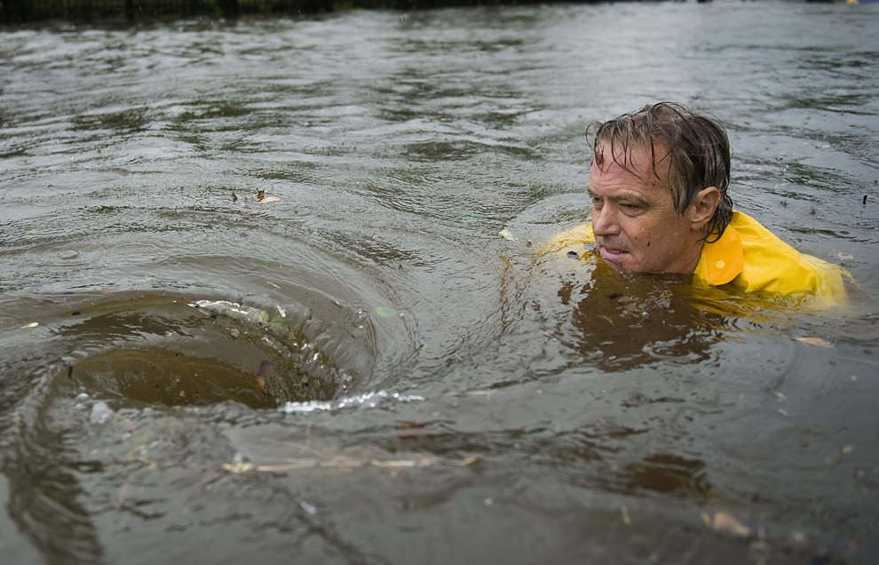
Before the bad news, here's a nice fun image of the happy side of storms:

Image

Enjoy it? Good, because things look really fucked up.

So, just woke up, straight on to the Batman-multi-screen Houston feed channel.

First thing's first. Anything at the moment is still speculation. Until daybreak in Houston six hours from now, we won't know anything concrete. Ike has now just landfall, and the eye is just moving over Galveston island now. Galveston is flooded, but to what extent no one knows. The reporters are on the tall hotels next to the sea wall, which is the third highest bit of Galveston aside from the 'building of last refuge' which is the High School and St Louie hotel at the highest point which is booked by emergency services. The latter St Louie hotel does have waist high water in the basement.

The big storm surge still hasn't hit yet, storm surges are pushed in front of a hurricane but they're also dragged, and when the wind directions switch on the other side of an eye, that's when the nasty stuff piles up.

Forecast is an 18ft-20ft Galveston Bay storm surge - this isn't a seawall/gulf water surge, this is the water that's being pushed from the big bay behind and onto land. So whether the wall is overtopped or not is sort of a moot point when it comes to flooding, the only thing the seawall overtop would add is battering-ram force waves.

Image
About seven hours ago... 18-20ft surge to come...

Here's Brendan Loy's latest update:

Quote:
11:35 PM EDT: Hurricane Ike will make landfall on Galveston Island in the next few hours. Massive ocean waves are bearing down on the vulnerable Texas coast, riding atop a freakishly huge storm surge that will be peaking while the tide is coming in. Needless to say, this is not a good situation.

I’ve decided not to stay up all night and liveblog, since it’ll probably be hard to tell just how bad the storm-surge flooding is till daybreak anyway. I figure it doesn’t make a lot of sense to stay up until shortly before dawn, and then go to bed, just when the extent of Ike’s impact is becoming clear. Instead, I intend to wake up around 6:00 AM EDT tomorrow, and resume blogging at that time.

In the mean time, you can follow Ike’s progress overnight via my various links in the sidebar at right, including links to other folks who are liveblogging. In addition, Houston Chronicle reporters are liveblogging, too. Michelle Malkin has more links. Last but not least, you can watch Ike’s storm surge in real time using the special surge data page I’ve created.

A very brief primer on Ike, for new readers: as I’ve explained repeatedly, Ike is a freak storm — not a “normal” Category 2 — and an extremely high storm surge, of Category 4 proportions, is widely expected by experts. Galveston’s seawall will probably be overtopped, and even if it is not, huge portions of the island will be flooded. Damage will be tremendous all throughout Galveston Bay and up the coast to Port Arthur and southwestern Louisiana. Moreover, with many thousands of people foolishly choosing to ride out the storm in vulnerable coastal areas, including Galveston Island itself, a very large death toll seems possible. I’ve titled this post “The Great Galveston Hurricane of 2008″ because I fear we may be calling it that soon enough.

I guess we can hope the surge projections are somehow flawed, due to the computer models failing to capture something about Ike’s bizarre structure, or whatever. In other words, we can hope against hope that things won’t be as bad as we presently fear. I don’t know that there’s any valid reason to hope that, but I’ll hope it anyway. Certainly, Ike’s winds are not going to be anything catastrophic, Geraldo Rivera’s theatrics notwithstanding. The storm surge is the issue here. And by all indications, it’s going to be terrible. But I’ll say a prayer that those indications are, somehow, wrong.

[UPDATE, 1:04 AM EDT: Okay, I’m not in bed yet — and I’ve found some reason to hope, for Galveston at least: “Regardless of whether the eye center passes just west, directly over, or just east of Galveston…I think the rightward jog that has occurred basically ensures that Galveston will miss the core of the highest storm surge. Remember, the region of maximum surge is actually pretty significantly further to the right of where the eye makes landfall . . . Galveston will still experience significant flooding, don’t get me wrong, but the absolute worst of the surge is almost certainly going to be farther east…affecting the Port Arthur/Beaumont/Orange area.” That’s according to a contributor at the Eastern U.S. WX Forums. Dunno if it’s right. Certainly, the worst of the surge being further up the coast is correct, but as for whether Galveston will avoid total destruction — we’ll find out in the morning, I guess. … And now, I’m really going to bed. Honest.]


So far no one has gone against the estimate of 40% of Galveston not evacuating. And worse news when a Houston official stated that he figured the percentage was the same for the storm surge zones around the rest of Galveston bay and the Houston fringe.

Houblog:

Quote:
GALVESTON — Despite a mandatory evacuation and ominous forecasts of a killer storm, police, firefighters and the Galveston Beach Patrol rescued dozens of residents Friday from the rising tides brought on by Hurricane Ike as it bears down on Galveston Island. Many had stayed on the island through numerous other hurricanes and were surprised by the height of the tidal surge. City officials estimated that as many as 40 percent of the island’s about 60,000 residents remained in their homes.

Good Lord. That’s twice what I expected. If that proportion is the same for for zones A and B (areas that “never flood”)…

US Census: Galveston county popuation, 283,551, for both island and mainland. Clear lake is 65k. Power’s getting iffy again, can’t research more.

Toss in southern Harris county near the bay, Chambers county and so on, if that % holds true, there could be 300,000-500,000 people at risk.


No idea if that's true or not. Personally, I can't imagine that many people being that stupid and my hunch would be exageration. But these are figures that are being bandied about a lot. What's certain is that there's a lot of annecodtal evidence of people staying. So there's at least a significant number in the thousands scattered around the bay who have chosen to ride it out.

Interviews from Fox news: (Yes, I know. Fox. Ugh.)

Quote:

SURFSIDE BEACH, Texas — Authorities say tens of thousands have ignored evacuation orders and are staying behind as Hurricane Ike takes aim at the Texas coast.

An Associated Press survey shows that in three counties alone, some 90,000 people have chosen not to leave despite dire warnings from forecasters.

The emergency management coordinator for Galveston County estimates that 80 percent of the residents evacuated. That leaves more than 11,000 residents in the county that is expected to take a direct hit from Ike's massive storm surge.

Farther up the coast, officials say half the residents of Beaumont stayed put less than two weeks after many evacuated for Hurricane Gustav, only to see the storm miss the city entirely.

At first, even the threat of "certain death" was not enough to persuade Bobby Taylor to flee this small town directly in the path of Hurricane Ike.

His wife, Elizabeth, had already decided to leave before police drove a dump truck through flooded streets, urging people to get out. Those who refused were told to write their names on their arms in black marker, so their bodies could be identified later.

Elizabeth came back to persuade her husband to leave and was waiting for him when he waded in waist-deep water up the main street, towing a blue kayak. She greeted him joyously. "Now I'll pray for our neighbors," she said.

More than a million people evacuated southeast Texas ahead of Ike. But citing faith and fate, tens of thousands more ignored calls to clear out, coastal authorities said. The National Weather Service warned that people in smaller structures in some areas "may face certain death."

The choice to stay — always questionable, sometimes fatal — was an especially curious one to make so close to Galveston, site of a 1900 storm that killed at least 6,000 people, more than any other natural disaster in U.S. history.

Mayor Larry Davison Davison said authorities had been told the man had left, but later saw him on his porch. He had no phone.

"When we finally saw him, it was too late to get back in there," the mayor said. "We had to retreat."

A mandatory evacuation order was in place, but there were no signs anyone was being forcibly removed.

"We're not going to drag them out of there and handcuff them," Davison said. "They've made their decision."

Forecasters said Ike could pack a 20-foot storm surge when it rolls ashore early Saturday near Surfside Beach. By midday Friday there was 5 feet of water in some places, with more coming in.

It was enough to persuade the Taylors' neighbors to relent. David Fields, 45, and wife Dondi, 50, had written their Social Security numbers on their arms. Dondi Fields added "I (heart) U" on her right arm — for her kids, she said.

"We didn't want anybody to have to risk their life to come and get us," Dondi Fields said.

Nearby Freeport was all but deserted, and quiet except for the increasingly roiling sea. Truck driver Darryl Jones Sr. and his neighbor, Keith Glover, talked about the impending hurricane without concern. Nearly everyone around them had obeyed a mandatory evacuation order.

"I'm just enjoying the serenity, really," said Jones, 48, sitting in his electric golf cart. "You never know what the aftermath might hold, but right now it's very peaceful."

Glover, who works for the nearby city of Clute, will work removing debris after the storm, but said he would have stayed anyway.

"Worrying's a sin," he said.

At By George Automotive repair shop, owner George Elizondo and others in Freeport gathered to grill chicken leg quarters, shoulder steak and tortillas with pico de gallo. Coolers from the nearby grocery store sat filled with soda and beer.

The hurricane block party tradition began with Hurricane Rita in 2005, when Elizondo and others stayed behind to offer mechanical help to anyone those heading out.

"If it really gets bad, we'll get in our trucks and we'll drive out," Elizondo said. "Where's the burden in that? We're driving, we're ahead of the storm and there's no one on the road. There's no danger for us."

Water already covered one low-lying road in Freeport near refineries and a listing shrimp boat. The road became an attraction for those who stayed. Truck after truck pulled up, drivers jumping out with video cameras in hand. One woman leaned comically into the wind, smiling for the camera.

"It's going to be fun," Jerry Norton said as he snapped a cell phone image of the flooded road. He said he was sending the picture to his children and grandchildren who fled inland to Austin.

Norton said he had filled his bathtubs with water — for drinking, but also for flushing toilets in case the sewer system breaks down. He bought groceries and secured doors and windows.

"If my stuff is going to get washed away, I'm going to watch it get washed away," Norton said.

Some who stayed behind in Galveston relied on faith. Retiree William Steally, 75, said he was planning to ride it out, but his wife and sister-in-law left Thursday.

"She got scared and they left. I told them I believe in the man up there, God," Steally said as he pointed to the sky. "I believe he will take care of me."

Others quieted their own concerns and rolled with it.

Clarence Romas, a 55-year-old handyman, said he would ride out the storm in his downstairs apartment with friends.

As for the "certain death" warning? "It puts a little fear in my heart," he admitted, "but what's gonna happen is gonna happen."


What? What the fuck?

'Mr Monster' has an excellent comment on the blog which echoes frustrations at the national media response and at the retards who have chosen to stay:

Quote:
Ike isn’t important to the legacy media, because it’s hitting where Rita failed to produce adequate carnage, while Gustav, heading back where Katrina became the opportunity to bash Bush, was the chance to push “McSame”.

The only other thing the authorities should have done was to tell people:

We can’t force you to leave, but if you’re going to stay, please take a Sharpie and write your name and address, and the phone number of your next of kin (excluding any others staying behind), on your belly. That will make identifying your corpse easier.

I know I probably sound like a broken record, but the way to conceptualize these evacuations is this analogy:

If there is “only” a 1/6 chance the storm will kill you, and a 5/6 chance of a “false alarm”, it’s exactly the odds for Russian Roulette. And we all think playing that game is stupid.


I have to say though, me and the hurricane blogging community are really impressed by the local Houston media. Currently a big restaurant fire and the Marina fire in Galveston are dominating in lieu of concrete information. At least three fires in the city. KPRC.com guy Robert Arnold on the scene worries that the water is getting dangerously near the top of the seawall, and the highest point San Louie Hotel, the water has now reached. I'm unsure if this is big wave splash coming over the wall, or bay water. Lots of unsure reports. The theorising is good though, and they seem to know the gravity of the situation. They're really delivering the message on the storm surge. So while CNN and MSBC and the other big channels fuck up and keep going on about 'category 2' and mouse-squeak warnings, the local channels are at least doing their job. I worry about how many stayed because they stuck with the underplayed, weak-coverage, 'let's grill Palin instead' style coverage.

Again, here's the brilliant Maroon Spoon 4-local-news-channel feed:

http://www.maroonspoon.com/wx/ike.html

Weathernerd blog: (Lots of links in a side panel)

http://pajamasmedia.com/weathernerd/

Dr Jeff Masters:

http://www.wunderground.com/blog/JeffMasters/show.html

Houston Chronicle Weather expert, forecaster and blogger Eric Berger:

http://blogs.chron.com/sciguy/

Last word from Eric:

Quote:
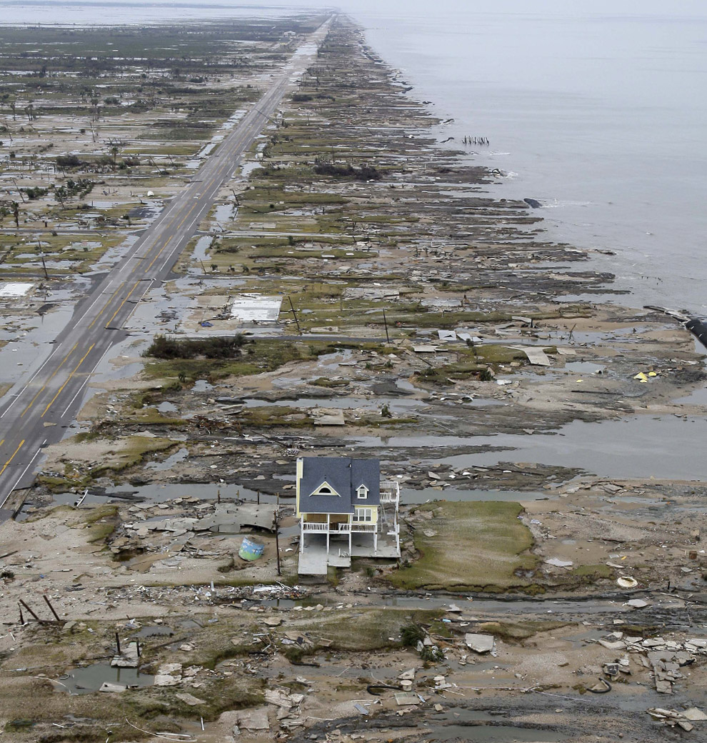
After New Orleans, Galveston is probably the second-most vulnerable Gulf Coast city to hurricanes. Like New Orleans, Galveston relies on long-sturdy walls to protect its structures.

And like New Orleans, Galveston may soon find out that there's no substitute for elevation.

About 40 percent of the city's 58,000 residents ignored calls to evacuate. And now they're phoning for help and getting this response, "We can't help you." I fear it's going to get quite grim. City Manager Steve LeBlanc went so far as to ask the media not to photograph "certain things" in the aftermath, referring to the possibility of dead bodies.

Galveston's founders, including Gail Borden Jr., the inventor of condensed milk, made a poor decision when siting their burg in 1836. The city rests on a barrier island, essentially a glorified sandbar.

Ever-shifting, barrier islands are transient coastal features. They gradually build up from silt and sand deposited on the coast by inland rivers. The state's barrier islands slowly have died as Texas has dammed up many of its rivers.

Five years ago public officials spent millions of dollars to renourish starving beaches on the western end of Galveston Island, adding acres of shoreline. That summer, a minor hurricane, Claudette, made landfall in Texas near Port O'Connor.

Although the storm only produced about 45 mph winds in Galveston, it stripped away one-third of the new beach. It will all be gone by early tomorrow.

The time for fun and games in Galveston has ended.

I noted on Wednesday night that I couldn't believe that the Galveston mayor hadn't yet called for an evacuation, and she finally did Thursday morning. Still, I feel that emergency planners weren't sufficiently firm in their warnings, leaving that job to the National Weather Service.

Sensing the danger, the weather service was left to writing messages such as, "Persons not heeding evacuation orders in single family one or two story homes will face certain death. Many residences of average construction directly on the coast will be destroyed. Widespread and devastating personal property damage is likely elsewhere."

Unfortunately this may now come to pass on an island where more than 20,000 people remain to ride out a monster hurricane.


Seven hours more of at least tropical storm winds, eye of hurricane will leave Galveston in 15 minutes roughly, then its back to the pounding.

I'm going to be away from computers - going cold turkey - and be unable to update until I get home tonight. Lave, if you or any others want to root around and put stuff up here, feel free. Cheers y'all.

_________________
"Peter you've lost the NEWS!"

Bored? Why not look at some pretty pictures on my photography blog? Here: http://petetakespictures.com

Come & See My Flickery Pics Here: http://www.flickr.com/photos/nervouspete/


Top
 Profile  
 
 Post subject: Re: Hurricane Ike - Shitting Crikey!
PostPosted: Sat Sep 13, 2008 9:10 
Excellent Member

Joined: 30th Mar, 2008
Posts: 489
Just been watching batman-o-vision.

The reports from within the eye of the storm were pretty freaky. Completely calm albeit with lots of flood water, but with the knowledge that the worst is yet to come. You can see how many people could be caught out thinking that it was over, hence all the warnings to stay inside.


Top
 Profile  
 
 Post subject: Re: Hurricane Ike - Shitting Crikey!
PostPosted: Sat Sep 13, 2008 15:38 
User avatar
Excellent Member

Joined: 30th Mar, 2008
Posts: 8019
Location: Cardiff
I've been run ragged running the turns-out-to-be-insanely-popular Roald Dahl day here in the Norwegian Chapel, so I've literally only had time to check the one blog just now. Since Loy's and Dr Jeff's don't agree with the internet in the tiny office here, I'll have to check up when I get home in two hours or so.

Eric Berger has grounds for optimism in this shock 'not as bad as initially feared' thing. Of course, the return surge of water headed back to the coast is yet to make effect, but these figures bode at massive property damage, but mercifully fewer casualties.

Be interesting to find how those initial projections of 17-20ft came about. Is this a case of false computer models causing overhype? It'd be a bit harsh to use that word, 12-14ft is still a bad storm surge, but it's not a catastrophic one. Again, this data has not been confirmed, and I don't have any other blog access.

Quote:
Did Southeast Texas escape the worst?
For a lot of residents it sure won't feel like it today, or in the coming weeks or months. But here's a preliminary assessment from University of Texas engineer Gordon Wells. I consider the information to be credible.

Galveston Island: Storm surge peaked at 12.4 feet at 02:12 CDT. That measurement places 6-7 feet of water in the bayside area of the city, including UTMB and The Strand.

Galveston Bay communities: All sensors failed during the rising stage of the surge, so no direct measurements are available. Based on the Galveston gage record, storm surge elevations in the communities along the bay and in the Houston Ship Channel should peak in the range of 12-14 feet.

Port Arthur: The gage at Sabine Pass peaked at 14.24 feet at 02:42 CDT. The Port Arthur gauge, which reports hourly, stood at 11.92 feet at 04:00 CDT and was still rising very gradually. It appears that the storm surge along the Port Arthur seawall will peak between 12 and 13 feet, or 1.5-2.0 feet below the threshold for overtopping. Unless the levee fails before water recedes, Port Arthur will survive Ike.

Comment: Damage from inundation caused by storm surge will be widespread across the region, but should not reach the catastrophic level that would have occurred, if several model predictions materialized. Heavy rains continue across the Houston metropolitan region, and bayou flooding may replace the storm surge threat, but if Ike exits the region on schedule, Southeast Texas will have escaped the worst.

All of this doesn't speak to the potential devastation in Galveston, especially for areas beyond the seawall on the island's west end. That's a story that will continue to unfold for days and weeks.

_________________
"Peter you've lost the NEWS!"

Bored? Why not look at some pretty pictures on my photography blog? Here: http://petetakespictures.com

Come & See My Flickery Pics Here: http://www.flickr.com/photos/nervouspete/


Top
 Profile  
 
 Post subject: Re: Hurricane Ike - Shitting Crikey!
PostPosted: Sat Sep 13, 2008 18:50 
User avatar
Excellent Member

Joined: 30th Mar, 2008
Posts: 8019
Location: Cardiff
PHEW.

Well, it wasn't as bad as feared. Storm surges were around 10-14ft instead of the 15-20-25ft predicted. This means the major oil facility Port Arthur with its 15ft wall is spared. Central Galveston is spared, but the East and West sides are inundated. No idea how Huston has fared yet. The Bay has flooded, and lots of rooftops are visible just above the water.

Winds were a little higher than anticipated, resulting in blown out glass sides in skyscrapers in the Huston area. Power is expected to be out for Galveston for a couple of weeks tops.

There's head scratching as to how the computer models failed. It seems that breadth of storm equaled duration of storm surge, with it arriving far earlier than normal, but not increased levels. This matches Alan Sullivan's early blog where he reckons on breadth over height, or rather, wider area than normal affected, but not as high as a category four.

So the centres are spared. But a lot of people chose to stay, and based on the warnings those people are idiots. Some may have lost their lives in the bay area. If damage turns out to be remarkably light in a swampy-not-smashy nature, this may mean trouble in the future as people REALLY set against evacuating, figuring property damage but ultimate safety. Which would be a bad idea when a real category four comes through.

Again, early after storm damage reports. But not near as bad as earlier "Shitting crikey!" posts I made thought would be. My prediction = lots worse than Gustav, not as bad as Katrina.

_________________
"Peter you've lost the NEWS!"

Bored? Why not look at some pretty pictures on my photography blog? Here: http://petetakespictures.com

Come & See My Flickery Pics Here: http://www.flickr.com/photos/nervouspete/


Top
 Profile  
 
 Post subject: Re: Hurricane Ike - Shitting Crikey!
PostPosted: Sat Sep 13, 2008 19:13 
User avatar
Excellent Member

Joined: 30th Mar, 2008
Posts: 8019
Location: Cardiff
Last post for a little while. Off to eat and watch a movie with friends. It's pretty much Brendan Loy's post. Sumarised, it says: "Don't trust computer models, trust your instincts," based on computer analysis versus - well - Alan Sullivan's analysis.

So far video footage shows smashed piers, roofs just above water, but critically many areas sodden or barely inundated. Naturally though they're taking footage of the least effected first, and will then move into the more difficult to access spot. So this is a long, long way from the 'storm of the century' predicted yesterday. But experts had more justification to worry and warn than Nagin did with Gustav. The fear is, if the toll is below or comparable with Rita's evacuation toll, people may never evacuate again. When it really is a good idea in a coastal flood zone.

Anyway, here's Loy's blog:

Quote:
I’m going to be traveling tomorrow, so I need to run some errands, pack for my trip, etc. In addition, my two alma maters, Notre Dame and USC, both have big games today, against Michigan and Ohio State, respectively. So I’m afraid I won’t be able to provide much aftermath coverage this afternoon and evening.

I recommend the various blogs and local media outlets listed in my sidebar at right. Local sites like the Houston Chronicle staff blog and the CBS 11 and ABC 13 blogs have more and better coverage of the storm’s impact than I could possibly do anyway.

* * * * *

Meanwhile, on the issue of Ike’s weaker-than-expected storm surge — which was destructive but not cataclysmic — Alan Sullivan has a good initial wrap-up post, which he calls the “Lessons of Ike.” He writes:

Let’s talk about coastal flood modeling. That went badly wrong yesterday. I used a common sense analogy to help readers understand how the sea surface deforms during hurricanes with different characteristics. When a hurricane is tightly wound like Charley, striking near Fort Myers, Florida in 2004, its core pulls up the sea like a pimple. When a hurricane is broad and comparatively weak, like Ike yesterday, the surface of the ocean resembles a hive — swelling covers a much larger area, but it has no sharp peak. I don’t know how the forecast models are constructed. I am not a mathematician or a meteorologist. But if the output of a computer defies common sense, it’s usually wiser to ignore the computer.

He then proceeds to discuss the possibility of “built-in bias” in models “devised by and for the government that wants to keep everybody safe from everything.” I’m a bit skeptical of that aspect of his analysis. I would imagine the models are designed to be as accurate as possible, and any “bias” caused by the “nanny state mindset” would come in with the interpretation of the models and dissemination of the model data to the public (see, e.g., “certain death“). I’m certain that the flaw in the modeling, whatever it is, that led to this major error, will be studied and, if possible, corrected. Even taking the most cynical view, false alarms do not advance any “nanny state” agenda. They detract from it, in fact, since they tend to cause people to grow cynical and trust the government’s warnings less. Surely even the most “nannyish” bureaucrat understands that.

But Sullivan’s “common sense” approach definitely has merit. Keep in mind, Sullivan, like me, is not a meteorologist; he’s just an amateur weather buff who likes to blog about hurricanes. It’s difficult and risky to challenge a consensus as strong as yesterday’s “storm surge catastrophe” conventional wisdom, especially when you’re not an “expert,” and all the experts are convinced by the models. So Sullivan deserves a lot of credit for bucking the CW. I was looking at the very same “common sense” facts that he was, but I assumed the experts and models were right, and thus came to the opposite conclusion. I don’t think this was unreasonable on my part — but it was, as it turns out, wrong, whereas Sullivan was right. That counts for something. Indeed, if you’ll indulge me for a moment, allow me to put it in perspective:

Three years ago, I got a bunch of attention in the media for, supposedly, presciently “predicting” Hurricane Katrina’s impact on New Orleans. This made for a good storyline — the 23-year-old law student in Indiana saw it coming, and President Bush didn’t! — but it was mostly nonsense. As I tried repeatedly, and usually in vain, to explain to various reporters, I didn’t really “predict” anything, and certainly nothing unique or extraordinary. I said what everyone “in the know” was saying about the threat to New Orleans; I just said it loudly and repeatedly, got Instalanched, posted frequent and link-rich updates, and ultimately built quite an audience. Sure, I was ahead of the curve as compared to the MSM and some elements of the government, but that’s about as difficult as being the best football team in the ACC. And anyway, countless meteorologists, disaster planners, other bloggers, and assorted weather nuts were just as “ahead of the curve” as I was.

Sullivan’s coverage of Ike is a different story. He truly stuck his neck out, and saw what the pros failed to see — twice.

1. First, at a time when the experts were nearly unanimous that Ike still had an excellent chance of intensifying explosively into a high-end Category 3 or 4, Sullivan dissented. “This is not The Big One — except in size,” he wrote Wednesday evening, predicting a “category one or two” landfall. “If Ike can develop no more than it has over the Loop Current, it will not be spinning suddenly to category four, fifty miles off Galveston.”

On Thursday morning, while many others were still waiting for Ike’s circulation to tighten, and its winds to rise in reaction to its pressure drop the previous night, Sullivan predicted that the storm would retain the “weird” internal structure that was preventing such strengthening. “Hurricanes often develop distinctive individual characteristics and retain them through much of their cycle,” he wrote. He said he doubted the NHC’s “concern that this sprawling system might contract (and thus develop stronger winds) just as it approaches the coast” would come to fruition. “Ike’s damage may be considerable, but it will be scattered and not record-setting in any one locality, IMO.”

On Thursday afternoon, Sullivan called Ike “overhyped,” saying, “The inner core has dissipated. We now have an eyeless hurricane with greatest winds in a ring far from the center. This is not a configuration for strengthening. This is not The Big One.” Gradually, the consensus evolved, and came around to Sullivan’s position: Ike would not strengthen significantly before landfall. This proved true, of course. Ike came ashore as a Category 2 — not the Cat. 4 monster once envisioned by forecasters.

2. Sullivan made his second bold prediction on Friday morning, as experts began to propound a new fear: that Ike, although not a “major hurricane” according to the Saffir-Simpson scale, would nevertheless produce a catastrophic storm surge, more typical of a Category 4 storm. This fear, it should be noted, was not based on “hype” or “hysteria,” but rather, on raw data: an Integrated Kinetic Energy level rarely seen in recorded history, and SLOSH computer models that predicted a storm surge of 15-20 feet — even 25 or 30 feet in some spots — along the vulnerable Texas coast. But, again, Sullivan dissented from the direst of forecasts:

Extreme surge scenarios are being propounded for this storm. I suspect we will learn that they are excessive. Ike is too broad and weak to follow models based on the tight core structure of a normal hurricane. The danger will arise not so much from the height and speed of surge; but from its duration, and the immense wave heights built in the huge storm. I do not believe any location will be as severely affected as Mobile Bay in Katrina, where surge heights really did exceed twenty feet. But the lesser surge of Ike will be spread along a much greater length of coast. It will be very destructive.

Analogy: The elevation of ocean surface resembles a pimple in a typical hurricane. Ike’s deformation of the sea will resemble a hive — broader and flatter.

Sullivan urged evacuation of vulnerable coastal areas, but described the National Weather Service’s “certain death” pronouncement as “over the top.” He also rejected commenter Steve Sadlov’s comparisons of Ike to a Gulf of Alaska storm or, worse, the North Sea flood of 1953. “But… it’s not all piling up in one place,” Sullivan wrote. “Remember my analogy: this is a hive, not a pimple.” Even as the advance storm surge, hundreds of miles from the storm’s center, seemed to confirm everyone else’s worst fears, Sullivan stuck to his guns. “I still doubt the extreme projections for surge height,” he wrote at 2:06 PM yesterday. “People have never seen the ocean rise before a hurricane, but this is a storm in a class by itself.”

A couple of hours later, Sullivan did say that “we may be looking at the most expensive hurricane in history,” and his concern grew last night. “Galveston will probably be a total loss,” he wrote. But he added that he still wasn’t “buying” the direst scenarios. “The trouble,” he wrote, was not the height of the surge itself, but “the track: right front of eye coming straight at the mouth of Houston Ship Channel — at high tide.” As he later explained:

When it appeared for a few hours that landfall would be 20-30 miles SW of where it actually was — and I was fully persuaded of that — I was alarmed about Houston. This was the one place where I thought it was possible that model heights might be better justified. If the course of the eye had held NW for longer, onshore wind would have kept piling surge into the mouth of the bay, while flooding rains fell inland.

But as soon as it became apparent the eye was coming right over Galveston, that concern was alleviated.

Bottom line: Sullivan never bought into the computer model scenarios. He trusted his “common sense.” The rest of us trusted the models. We were wrong. He was right.

Importantly, Sullivan’s wrap-up post explicitly endorses the wisdom of evacuations, and chides those who failed to get out of harm’s way:

No matter what the controversies about models or codes, when a hurricane approaches, coastal residents should secure their property and leave, if they live in flood zones or flimsy buildings. What good is the security of a brick house, if it is only one story high, and water fills it to the ceiling? What protection is a mobile home on high ground, when the big pine blows on top of it?

This, too, is a matter of “common sense,” he says. Indeed.

For what it’s worth, I stand by everything I have posted here on Ike. I believe the information I disseminated, and the warnings I relayed, were accurate and reasonable at the time I posted them. And that, as I know Sullivan would agree, is the only standard by which statements about hurricanes can be fairly evaluated: the standard of contemporaneous reasonableness, not 20/20 hindsight. I don’t believe my dire warnings about Ike’s potential were “hype,” so long as they are understood as just that: warnings about potential, not statements of certainties.

Alan and I looked at the same information and interpreted it differently. I think both interpretations were plausible, and I think I stated things reasonably. As it turns out, though, my interpretation (and nearly everyone else’s) was correct, and Sullivan’s was incorrect. So kudos to him. *tips cap*

_________________
"Peter you've lost the NEWS!"

Bored? Why not look at some pretty pictures on my photography blog? Here: http://petetakespictures.com

Come & See My Flickery Pics Here: http://www.flickr.com/photos/nervouspete/


Top
 Profile  
 
 Post subject: Re: Hurricane Ike - Shitting Crikey!
PostPosted: Mon Sep 15, 2008 9:56 
User avatar
That Rev Chap

Joined: 31st Mar, 2008
Posts: 4924
Location: Kent
Looks like my area of Houston got away with it. Power outages and, possibly, contaminated tap water, roads barely flooded, a few trees in houses, but it's not as bad as it could have been.

_________________
InvertY


Top
 Profile  
 
 Post subject: Re: Hurricane Ike - Shitting Crikey!
PostPosted: Mon Sep 15, 2008 12:29 
User avatar
Excellent Member

Joined: 30th Mar, 2008
Posts: 8019
Location: Cardiff
Yeah, it was no where near as bad as the computer models projected. The surge around ten feet lower in many places. However, there was still a lot of devestation along the edge of the bay and Bolivar Peninsula on Galveston Island is completely gone. If the storm had tracked a little more South West by about 25 miles and more, things would have been a lot worse. As it was, it finally made landfall directly over the island, sparing it catastrophic damage.

The rubble is still being picked over in a lot of places, and the full picture still isn't clear. I wouldn't say 'bullet dodged' as there are a lot of houses and interiors completely wrecked. This certainly wasn't the 'certain death' storm it could have been though. I'll do a full update later when we know a lot more about what happened and assessments start coming in.

Houston was lucky though. Ripped up roads, downed trees, glass all over the place, but everything repairable within a couple of months tops.

_________________
"Peter you've lost the NEWS!"

Bored? Why not look at some pretty pictures on my photography blog? Here: http://petetakespictures.com

Come & See My Flickery Pics Here: http://www.flickr.com/photos/nervouspete/


Top
 Profile  
 
 Post subject: Re: Hurricane Ike - Shitting Crikey!
PostPosted: Mon Sep 15, 2008 13:03 
User avatar
Ticket to Ride World Champion

Joined: 18th Apr, 2008
Posts: 11843
Boring! >:( Roll on Hurricane Jaja for a bit more entertainment. Who says we have become desensitised?

_________________
No, it was a giant robot castle!


Top
 Profile  
 
 Post subject: Re: Hurricane Ike - Shitting Crikey!
PostPosted: Mon Sep 15, 2008 18:40 
User avatar
I forgot about this - how vain

Joined: 30th Mar, 2008
Posts: 5979
Bobbyaro wrote:
Boring! >:( Roll on Hurricane Jaja for a bit more entertainment. Who says we have become desensitised?


If you think this has been a non event look at these pictures of the aftermath.

http://www.boston.com/bigpicture/2008/09/the_short_but_eventful_life_of.html

They are pheneomenal. And horrendous.

_________________
Curiosity wrote:
The Rev Owen wrote:
Is there a way to summon lave?

Faith schools, scientologists and 2-D platform games.


Top
 Profile  
 
 Post subject: Re: Hurricane Ike - Shitting Crikey!
PostPosted: Mon Sep 15, 2008 19:02 
User avatar
baron of techno

Joined: 30th Mar, 2008
Posts: 24136
Location: fife
Woah, those are 8)

http://cache.boston.com/universal/site_ ... /ike19.jpg


Top
 Profile  
 
 Post subject: Re: Hurricane Ike - Shitting Crikey!
PostPosted: Mon Sep 15, 2008 19:49 
User avatar
Ticket to Ride World Champion

Joined: 18th Apr, 2008
Posts: 11843
http://cache.boston.com/universal/site_graphics/blogs/bigpicture/ike_09_15/ike11.jpg

Is this Ned Flanders' house?

http://cache.boston.com/universal/site_graphics/blogs/bigpicture/ike_09_15/ike25.jpg

I can't believe that the no one fell out of the boat when the hurricane put it on that truck!

_________________
No, it was a giant robot castle!


Top
 Profile  
 
 Post subject: Re: Hurricane Ike - Shitting Crikey!
PostPosted: Mon Sep 15, 2008 19:57 
User avatar
baron of techno

Joined: 30th Mar, 2008
Posts: 24136
Location: fife
I hope no-one fell out of that boat when the hurricane put it on that car :)
http://cache.boston.com/universal/site_ ... /ike17.jpg


Top
 Profile  
 
Display posts from previous:  Sort by  
Reply to topic  [ 89 posts ]  Go to page Previous  1, 2

All times are UTC [ DST ]


Who is online

Users browsing this forum: PRISM and 0 guests


You cannot post new topics in this forum
You cannot reply to topics in this forum
You cannot edit your posts in this forum
You cannot delete your posts in this forum
You cannot post attachments in this forum

Search within this thread:
You are using the 'Ted' forum. Bill doesn't really exist any more. Bogus!
Want to help out with the hosting / advertising costs? That's very nice of you.
Are you on a mobile phone? Try http://beex.co.uk/m/
RIP, Owen. RIP, MrC.

Powered by a very Grim... version of phpBB © 2000, 2002, 2005, 2007 phpBB Group.